
Pueblo Colorado
Galisteo Basin Sites
- Lamy Jct
- Lower Arroyo Hondo Pueblo
- El Camino Real
- Chamisa Locita
- El Crestón
- Espinoso Ridge Pueblo
- La Cienega Pueblo (LA 3)
- La Cienega Pithouse Village
- La Cieneguilla Pueblo (LA 16)
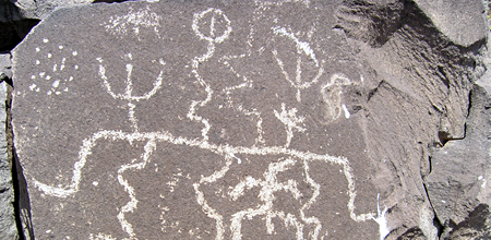
- La Cieneguilla Petroglyphs
- Manzanares Pueblo
- Paa-ko
- Petroglyph Hill
- Pueblo Blanco
- Pueblo Colorado
- Pueblo Galisteo
- Pueblo Largo
- Pueblo San Cristóbal
- Pueblo San Lazaro
- Pueblo Shé
- Rote Chert Quarry
- San José de Las Huertas
- Upper Arroyo Hondo Pueblo
- Pueblo San Marcos
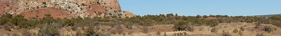
Pueblo Colorado is at the base of a vertical sandstone escarpment rising about 250 feet above the surrounding terrain.
It is adjacent to the Arroyo de la Jara which often has water in it, and by a side canyon where springs are present at the base of the sandstone cliffs. Tano descendants resident at the Keres pueblo of Santo Domingo Pueblo claim the ruins of the Galisteo Basin as ancestral villages and refer to LA 62 as Tze-man Tuo, or “place where the eagle’s claw is inside.” The name Pueblo Colorado was coined by N. C. Nelson (1914), referring to the red sandstone cliffs and building stone found there.
Pueblo Colorado (LA 62) includes three (possibly four) components: two or three
prehistoric and one historic. The earliest prehistoric component is represented
by a dispersed artifact scatter, primarily chipped stone, below the east-facing
cliff, 400 to 500 m south southwest of the spring. Obsidian, basalt, and
rhyolite are common material types in this area, hinting at a late Archaic
occupation, which is supported by the identification of a corner-notched dart
point. Immediately southwest of this dispersed artifact scatter is a late
Developmental (AD 1075–1175) habitation area represented by a moderately dense
artifact scatter and dispersed sandstone cobbles  within a stand of saltbush.
Although no “mound” or depressions were observed, this area likely contains 6
to 10 jacal rooms and 1 to 2 pit structures. The principal occupation is the
large Classic-period village of Pueblo Colorado proper. Nelson (1914) reported
11 roomblocks and estimated 881 rooms. Two linear east-west roomblocks define
the northern limit of the building, and a third defines the southern limit. A
single detached north-south roomblock lies to the west. North-south roomblocks
articulate with east-west buildings, forming two enclosed plazas in the western
portion of the village. Nelson excavated 40 rooms, primarily in Roomblock IV in
the northwest part of the site. To the northeast other smaller plazas were
formed within detached L-shaped roomblocks. It is within these L-shaped plazas
that the only kiva depressions are apparent. The largest plaza, however, is
also L-shaped, bounded on the west by one of the north-south roomblocks that
form the enclosed plazas and the southern east-west roomblock. Ceramic cross-dating
suggests that the principal occupation occurred between AD 1325 and 1500.
within a stand of saltbush.
Although no “mound” or depressions were observed, this area likely contains 6
to 10 jacal rooms and 1 to 2 pit structures. The principal occupation is the
large Classic-period village of Pueblo Colorado proper. Nelson (1914) reported
11 roomblocks and estimated 881 rooms. Two linear east-west roomblocks define
the northern limit of the building, and a third defines the southern limit. A
single detached north-south roomblock lies to the west. North-south roomblocks
articulate with east-west buildings, forming two enclosed plazas in the western
portion of the village. Nelson excavated 40 rooms, primarily in Roomblock IV in
the northwest part of the site. To the northeast other smaller plazas were
formed within detached L-shaped roomblocks. It is within these L-shaped plazas
that the only kiva depressions are apparent. The largest plaza, however, is
also L-shaped, bounded on the west by one of the north-south roomblocks that
form the enclosed plazas and the southern east-west roomblock. Ceramic cross-dating
suggests that the principal occupation occurred between AD 1325 and 1500.
Within this bounded space is a large C-shaped water-control feature interpreted as a reservoir. A carpet of artifacts is present within the architectural area, with mounded refuse present to the north and south of the east-west roomblocks. This core area measures 200 m north-south by 300 m east-west. Outside this core area relatively few artifacts were identified, typically occurring in isolated concentrations, perhaps fieldhouse locations. Other prehistoric features within the site boundaries include an isolated wall approximately 400 m to the northwest in the direction of the spring, constructed of small unshaped sandstone boulders. This feature runs east from the arroyo to the base of the cliff, where it becomes increasingly less discernible. A shrine consisting of a circular arrangement of rock with an opening to the east defined by upright slabs is positioned on a low rise approximately 130 m south southwest of the village. Finally, dozens of petroglyphs and pictographs were identified along the cliff face and boulders north of the Classic-period village.
The historic component consists primarily of the remains of a nineteenth-century homestead and associated features, including a house, barn, and a corral. This occupation took advantage of readily available building materials and the enclosed plaza of Roomblocks II and III illustrated on Nelson’s map (1914). It is quite possible that the reservoir is associated with this or another historic component. Collections from Pueblo Colorado are held at the Laboratory of Anthropology. H. P. Mera's original collection of sherds from LA 62 and the American Museum of Natural History.
The site is HPD No. 107 in the State Register of Cultural Properties. It is entirely privately owned.

Featured Site
Petroglyph Hill
The site of Petroglyph Hill is located near the historic village of Galisteo...
More about Petroglyph Hill »© New Mexico Office of Archaeological Studies, a division of the New Mexico Department of Cultural Affairs.
The Center for New Mexico Archaeology
7 Old Cochiti Road
Santa Fe, NM 87507
505-476-4404
Fax: 505-476-4448