
Climate
Climate
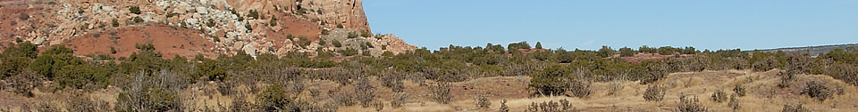
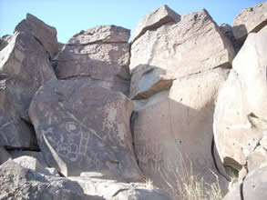
The Galisteo Basin has attracted archaeological and public interest for more than a century due to the dramatic and well-preserved landscape, impressive ruins with hundreds-to-thousands of rooms, world-class rock art, and dramatic roles in Spanish Colonial history, from the Entrada to the Pueblo Revolt (Lippard 2010; Mednick 1996). The underlying factor in the modern landscape preservation of the Galisteo Basin is a simple observation: today the region is suitable for ranching but not farming. Maize cannot be dry-farmed in the Galisteo Basin today, and yet we have significant evidence of large pre-Spanish Pueblo communities that clearly were subsisting on maize as the staple of their economy. The implication is that past climate change has had a substantial impact on the human use of this region.
If we use changes in the human economy as a measure of where to look for past climate change, we should look to the AD 1190-1500/1700 period. Although direct archaeological information on farming in the Galisteo Basin is sketchy, the earliest farmsteads fall within the AD 1180-1210 period. From that point, population appears to increase until about AD 1500 when settlements in the southern Galisteo Basin are abandoned. Spanish missionization at the beginning of the 17th century added a new ranching lifeway and new crops (wheat and rye) to what appears to have been a declining maize farming adaptation, but after the successful Pueblo Revolt of 1680, farming ceased to be a way of life in the Basin.
Climate Records
Tree-ring based climate reconstructions provide our most precise window on detailed climate variation. Northern New Mexico climate reconstructions for the period of interest (circa AD 1100 through AD 1600) include Palmer Drought Severity Indicies (PDSI) (Orcutt 1991) and precipitation reconstructions (Rose et al. 1981). The underlying data are substantially similar, but the transformations and presentations differ.
Orcutt’s summation consists of five-year running means of PDSI values, plotted on the fifth year. Her presentation begins at AD 1150, but it records the end of the Northern Rio Grande manifestation of the mid-12th century drought. The PDSI values reflect a brief strong positive moisture record for the late 1190s through early 1210s, coincident with the initial agricultural colonization of the Galisteo Basin. Significant negative values follow, and the 1230s through 1300 experience a few wet periods contrasted with more persistent and deeper dry periods that are nearly continuous from the 1270s through 1300. Nearly two generations of positive precipitation values, with almost no drought periods, characterize the 1300-1335 period. A deep and persistent drought lasts until the 1350s, and the remainder of the 14th century is a period of brief low amplitude oscillations between dry and wet periods. AD 1400-1405, the threshold of large pueblo formation, is a five-year period of sharp drought, and the remainder of the 15th century is generally dry with decade-long wet periods beginning in the late 1420s and 1485. After a wet period that lasts until 1495, and through 1575, the 16th century has low amplitude oscillations between short wet and dry periods. At 1575, a protracted and severe drought strikes that persists for a generation until 1595.
Rose et al. (1981) reconstructed past annual precipitation estimates based on data from Santa Fe, Arroyo Hondo, and Glorieta Mesa. These are presented as departures from the mean, with 10-year means plotted every five years. The 1130s drought is the deepest and most persistent of the summary, but conditions oscillate around “normal” until the 1190s. Nearly 20 years of strong precipitation are centered near AD 1200. Drought periods at 1220 and in the 1250s and mild wet periods in the 1230s and 1290s are the highlights of relative low variability through the 13th century. A short severe drought at AD 1420 is followed by brief wet periods at 1430 and 1440. With only minor wet and dry from departures from “normal,” the 1450-1600 period is one of relatively low amplitude variation. The 1560s through 1585 are characterized as a period of persistent negative departures but within the statistically normal range.
Tree-ring records of cold temperatures (shortened growing seasons at higher elevations, more effective moisture at lower elevations) are much more limited than precipitation records. Two high elevation tree-ring series have been applied to Southwestern climate reconstructions, one from Almagre Mountain (Petersen 1988) and one from the San Francisco Peaks (Salzer 2000). Petersen’s use of Almagre Mountain in his Southwestern Colorado climate reconstructions was initially dismissed as being non-applicable to the Southwest (Van West 1990). The subsequent development of the San Francisco Peaks record substantially parallels the Almagre record, validating the applicability of both to the Southwest region as a whole (Salzer 2000).
These records include a protracted cold period, initiated in the 1180s-1190s and persisting through the mid-13th century. Additional cold periods occur in the mid 14th century, and from the 1430s through the early 16th century. These variations don’t stand out particularly, and by themselves they don’t suggest a
categorical change in regional climate that would constitute shift to an agriculture-compatible climate in the Galisteo Basin. However, Petersen (1988) links the protracted continental cold with systematic modifications to the monsoon rainfall pattern in the Southwest: delayed onset and shallower penetration of the moisture laden air masses into the continental land mass. This model was proposed (and criticized) based on its relevance to the Four Corners area, but there are implications for the rest of the Southwest as well (from the northern Rio Grande Valley to Chihuahua).
The most intriguing element of current Southwestern climate models is the identification of a climate anomaly in a principal components analysis (PCA) of tree-ring chronologies from across the greater Southwest (Dean and Funkhouser 1995). Data for the study were averaged for 100 year periods, beginning in 689 and overlapped by 50 years. The study revealed a relatively consistent or “normal” pattern of spatial variability for most of the record, interpreted to reflect the modern pattern of bimodal (summer and winter) precipitation to the northwest and unimodal (summer) precipitation to the southeast (including the Galisteo Basin). This normal pattern gave way to a more chaotic situation for the AD 1239-1488 data aggregation periods. However, because of the aggregation intervals used, the disruption of the normal pattern was initiated at some point within the AD 1189-1239 period and returned to “normal” at a point within the AD 1489-1539 period.
Interpretation of this anomaly has focused on the Four Corners area (Cordell et al. 2007; Van West and Dean 2000), but the timing is remarkably coincident with the pulse of agricultural exploitation of the Galisteo Basin. The nature of the PCA pattern during the anomaly is that there is greater spatial coherence of tree growth in the southeastern than the northwestern zone. There has been a tacit assumption that this represents a persistence of normal conditions in the southeast, but that need not be the case. The minimal implication of the PCA is one of synchronic coherence rather a lack of diachronic change, and the anomaly may have been characterized by a new climate pattern over the Galisteo Basin and central New Mexico as a whole.
Unfortunately, we have no systematic and independent environmental observations for the Galisteo Basin. Fortunately, we have a variety of anecdotal observations that suggest potential yields from future research. I focus on two Galisteo Basin Pueblos that I know well: Pueblo San Lazaro and Pueblo San Cristobal. These pueblos are cut by deep arroyos that have reached a bedrock-controlled base level, exposing both natural and cultural deposits in the cut banks, and they represent both ends of the alluvial chronology sequence.
San Lazaro
In the late 1980s, a consortium of Southern Illinois University and the Museum of New Mexico conducted mapping and test excavations at San Lazaro Pueblo, supported by funds provided by the owner, Mr. Forrest Fenn. A cut bank created by the Arroyo Chorro exposed stratigraphic profiles through rooms and midden deposits, and a pit structure was exposed at the base of the cut. The pit structure’s surface of origin was near the modern arroyo base level, and the pit structure was associated with black-on-white pottery. Masonry rooms exposed in the cut bank above had floors more than two meters below the surrounding plaza surfaces. These rooms were filled with laminated sands and silts, reflecting short depositional events with little evidence of structural collapse. The rooms were surmounted by later masonry rooms associated with the higher elevation of the 15th century plaza surfaces. A midden at the elevation of the buried room floors had been cut by the modern arroyo and was dominated by Galisteo Black-on-white with a scattering of Glaze A Red, dating the midden to the 14th century.
The early pit structure was constructed adjacent to the arroyo when the base level of the Arroyo Chorro was at its bedrock-controlled low elevation. Early rooms were also constructed adjacent to the arroyo at slightly higher elevations, but they were abandoned and subsequent construction was placed well above and further back from the arroyo. My presumption is that the floodplain was aggrading dramatically through the 14th and early 15th centuries. Stratigraphic observations that would distinguish room fill through architectural degradation vs. slack water inundation have not been made, but no evidence of catastrophic flooding has been observed in the arroyo profile. The model-to-be-tested is that the 14th and 15th century occupation of San Lazaro Pueblo was characterized by high effective moisture and aggradation which forced residents of the pueblo to move back from their first homes adjacent to the floodplain and arroyo.
San Cristobal
San Cristobal Creek has been downcut to bedrock, and lateral movement of the channel is threatening the pueblo’s southeastern plaza and roomblock complex with erosion along a steep cut bank. The erosion is currently sectioning a large masonry-lined pit structure that has no visible surface depression on the flood plain above, contrasting with a later pit structure that is clearly evident back from the cut bank and at a slightly higher elevation. No date estimate is available for the sectioned structure, but it was abandoned and filled completely with laminated sediments while the roomblocks further from the creek were still occupied. The glaze ware types associated with this portion of the site are pre-Spanish, dominated by rim forms B, C, and D. There is no evidence of high energy deposition within the pit structure fill, but low energy deposition completely filled and obscured the pit structure location.
The more stark contrast at Pueblo San Cristobal is the landform segregation of the mission and convento complex from the Puebloan roomblocks and plazas (Huelster and Toll 2009:Fig. 5). The mission and convento were built on a broad flat expanse of floodplain surface at the toe of the higher landforms on which the Puebloan roomblocks and plazas were constructed. If floodplain aggradation had been active in the 17th century, this construction location would have been untenable. The lack of Puebloan construction of any age on the same landform suggests that the construction at that elevation was off-limits within the memory and traditions of the residents. Whether consciously or not, the mission exploited a newly stable landscape surface that was created and preserved by cessation of the previous period of floodplain aggradation.
Conclusion
Due to dependence on an agricultural economy, the rhythm of the Puebloan culture history in the Galisteo Basin was controlled by an underlying rhythm of climate change. Since today’s climate will not support maize agriculture, we look to the past for evidence of both farmers’ settlement decisions and climate change. The mid-12th century drought that marks the end of Chaco as a central place was also expressed in the Rio Grande Valley. We see the first movements of Northern Rio Grande farmers onto the Pajarito Plateau (Harmon and Vierra 2008; Orcutt 1999), and by the late 12th century into the Galisteo Basin. This initial movement coincides with both a clearly defined moist period between AD 1190-1210 and the onset of a continental cold period. Both the cold and wet may be correlated with the onset of a categorical change in Southwestern climate as documented in the PCA of tree growth (Dean and Funkhouser 1995). This change, bracketed within the AD 1189-1539 period, not only allowed maize agriculture in the Galisteo Basin, but it may have redefined agricultural potential from the Four Corners (negatively) to northern Mexico (positively).
In the Galisteo Basin, the apparent environmental consequence of the climate change was an increase in effective moisture (flood plain aggradation). In the complicated scenarios of Southwestern climate systems, it is tempting to interpret the nature of the categorical climate change as the persistence or even slight intensification of the summer monsoon pattern (moisture that was no longer reliably begin delivered to the Four Corners area), coupled with a stronger and more consistent pattern of winter moisture. More winter moisture would stabilize the landscape with more spring vegetation, as well as preparing the soil moisture balance for more reliable germination conditions for maize agriculture.
Human response to the new agricultural niche was immediate (late 12th century) and progressive (through the 13th and 14th century). The only detailed investigations to date are at the northeastern portion of the Basin, and they point to homesteading by populations with ties to Rio Grande Valley, not the San Juan Basin (Wilson 2008). No site-unit-intrusions that can be linked to “Mesa Verde migrants” have been identified despite intensive if unsystematic searches (see Dutton 1964), although one component at Pueblo Colorado with pottery reminiscent of Middle Rio Grande affiliations hints that the search for migrant origins needs to keep a broad focus (Steven A. Lakatos and C. Dean Wilson, personal communication, 2010).
The super-pueblo phenomenon in the Galisteo Basin appears to be a discrete period of aggregation that begins about AD 1400. The identification of environmental correlates of the aggregation is weak in measures of both temperature and precipitation. This lack apparently validates the investigation of social
variables (conflict or threat of conflict) in the decisions to aggregate. PDSI values are dominantly negative through the middle 15th century, with a longer period of cooler temperatures. Nothing in either the annual precipitation or temperature reconstructions suggests a crisis or tipping point at the start of the super-pueblo abandonment at about AD 1500. However, warmer temperatures and severe drought in the PDSI record define the threshold of Spanish colonization in the 1590s.
While the slow 16th century decline and abandonment of the southern Galisteo Basin is poorly explained by the annual record of precipitation and temperature, it is coincident with the macro-climate anomaly identified by Dean and Funkhouser (1995). The return of the “normal” geographic pattern of tree growth coincides with: 1) the progressive abandonment of the Galisteo Basin Pueblos; 2) the precipitous decline in Northern Rio Grande population (see Dean et al. 1994:Fig. 4.9 [but with the proviso that the population peak should be pushed later from AD 1300 to circa 1450, eg. Maxwell 1994]); and 3) the transformation of Apachean occupants of the Four Corners region into horticulturists (Wilshusen 2010). Petersen’s (1988) moving agricultural window is a useful analogy, but at an interregional scale.

Featured Site
La Cienega Pueblo (LA 3)
The La Cienega Pueblo and Petroglyphs site (LA 3) is also known as Pueblo Mesita and Pueblo Cienega...
More about La Cienega Pueblo (LA 3) »© New Mexico Office of Archaeological Studies, a division of the New Mexico Department of Cultural Affairs.
The Center for New Mexico Archaeology
7 Old Cochiti Road
Santa Fe, NM 87507
505-476-4404
Fax: 505-476-4448