
Pre-Columbian
Pre-Columbian
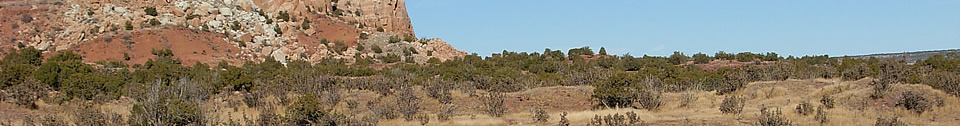
The Galisteo Basin reflects the pace and trajectories of more than 16,000 years of Native American history in North America. Initially, the Basin probably played little more than an occasionally resting point or kill or harvest site in seasonal rounds that encompassed huge portions of the Southwest. The corresponding density and visibility of archaeological sites is low, marked by little more than diagnostic styles of spear and dart points. As communities grew in population, and especially with the advent of maize in the last 3500 or more years, traces of human presence become more common. With true dependence on maize over the last 1500 years, and driven in part by changes in climate that were intimately tied to the success of agriculture, the archaeological record becomes more visible, more abundant, and more unique in terms of its rhythm and content.
First Americans
Advances in our understanding of the peopling of the Americas are coming rapidly on many fronts. Unconfirmed patterns and models from archaeology, geomorphology, and genetics suggest that the first migrants from Asia may have been present well before the ice-free corridor of 14,000 calendar years ago and perhaps as early as before the last glacial maximum of 28,000 to 22,000 calendar years ago. Even if this early model remains unsubstantiated, existing data support an arrival of humans in the range of 16,000 to 15,000 calendar years ago, followed by another wave in the 14,000 to 13,000 range. This latter group includes the archaeological culture of Clovis and represents the initiation of the Paleoindian period. No sites of this age have been documented in the Galisteo Basin or northern New Mexico, but discoveries remain possible. [Dates are expressed in calendar years ago, reflecting the translation of radiocarbon dates to calendric dates through calibration curves developed by radiocarbon dating of tree-ring sequences of known ancient age. The amount of radiocarbon in the atmosphere has not remained constant through time, so that radiocarbon dates on ancient plants and animals can be significantly different than the calendar age when they were alive.]
Paleoindian
As the last ice age gave way to our modern climate, human bands coexisted with extinct animals on a rapidly changing landscape. The earliest well defined traces of human presence in New Mexico are called Clovis (circa 13,000 calendar years ago), followed by Folsom (circa 12,500 years ago). Both “cultures” are named for archaeological sites in northeastern New Mexico where their distinctive spear points were found with massive animal bones at kill sites. These peoples hunted both modern and extinct animals and gathered wild plant foods, traveling over territories of hundreds of square miles. As their populations increased and as the environment warmed to approximate that of the present, daughter cultures differentiated in smaller territories, giving rise to what archaeologists characterize as various “late Paleoindian” cultures.
Probable late Paleoindian stone
tools have been discovered in the Galisteo Basin, 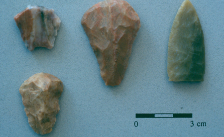 but even though no Clovis and Folsom sites have been
reported, we can infer their presence from distinctive artifacts that have been
discovered in the surrounding region. A Clovis spear point base was found by a
family on their property near Glorieta, and Folsom points have been found just
east of the Rio Grande back from the La Bajada escarpment. Ice age mammoth
skeletons and bones have been found eroding from arroyos and during road
construction just outside of the Basin, and it’s easy to imagine elephants,
giant bison, and even musk ox grazing across the immediately post-glacial
landscapes of northern New Mexico.
but even though no Clovis and Folsom sites have been
reported, we can infer their presence from distinctive artifacts that have been
discovered in the surrounding region. A Clovis spear point base was found by a
family on their property near Glorieta, and Folsom points have been found just
east of the Rio Grande back from the La Bajada escarpment. Ice age mammoth
skeletons and bones have been found eroding from arroyos and during road
construction just outside of the Basin, and it’s easy to imagine elephants,
giant bison, and even musk ox grazing across the immediately post-glacial
landscapes of northern New Mexico.
Archaic
With the extinction of the ice age animals and the stabilization of the modern climate, the Galisteo Basin took on its modern appearance of a mosaic of ecological zones. The diversity of plants and animals within short distances, and proximity to both the high mountains and the Rio Grande Valley, created a productive landscape for the continued population growth of human communities. Distinctive dart points, from spears that were thrown with an atlatl, are common discoveries in the Basin. Dark stains and concentrations of fire-cracked rock mark the presence of Archaic period pit houses (probably winter homes) and roasting pits. Dart point styles that have been observed in the Galisteo Basin reflect all parts of the Archaic time span, from 8000 years ago until 1500 years ago.
Although maize was grown in portions of the upland Southwest for at least the last 3500 years, this domesticated crop had little effect on the Archaic way of life in northern New Mexico as a whole. Bands of hunters and gatherers migrated from camp to camp harvesting animals and plants in their seasons of abundance. They were attracted to permanent water sources, and where archaeologists find evidence that they grew maize the farmers don’t appear to have been dependent on it for survival. Perhaps the diversity of other resources made farming an unnecessary chore, or perhaps the climate of the time was just marginal enough that the risks of being dependent on maize were too great.
Formative
Despite the slow shift to dependence on maize, the shift was inevitable as regional populations increased, marking the beginning of Puebloan prehistory in the region. While the Puebloan period is relatively well known to the public from places like Chaco Canyon and Mesa Verde, the content and chronology is somewhat different in the Rio Grande Valley (including the Galisteo Basin). The two chronologies are portrayed side by side in the accompanying chart. The cultural changes that mark the transitions between periods did not necessarily happen at the same time across the subregions of the northern Rio Grande, and some boundaries are more gradual than others.
Early Developmental Period (AD 400/600-900)
Seventh century farming communities are common in the valleys and mesas downstream from the Cochiti area (below White Rock Canyon and the La Bajada escarpment) along the Rio Grande and westward toward the San Juan Basin. At this same time, an Archaic lifeway persisted until about AD 900 upstream from, and east of, the Cochiti area, including most of the Galisteo Basin region. A seventh century maize storage feature was discovered in Santa Fe, but farmsteads were few and far between, if present at all, and the population might be better described as one of gardeners than farmers. Occasional pottery from the farming settlements in the Cochiti area is found in the Galisteo Basin, as are arrow points associated with long distance parties that hunted in the area. If early farmers did try to settle the Galisteo Basin before AD 900, their efforts were shortlived, undermined by a fickle climate or by the dangers of isolation. It’s likely that the mix of cultures across northern New Mexico as a whole was similar to the mix encountered by the Spanish—sparse populations of Archaic-style hunters and gathers living at the margins of successful farming communities.
Late Developmental Period (AD 900-1175)
Beginning about AD 900, agricultural communities spring up in the northern Rio Grande Valley upstream from the Cochiti area, from the Santa Fe region and eventually up into the Taos Valley. Although contemporary with San Juan Basin developments such as the Chaco ceremonial system, only a small amount of trade pottery suggests interaction between the Northern Rio Grande and the populations to the west. Pottery dating to this period is found at sites in the greater Galisteo Basin, but the nature of the sites suggests only brief excursions rather than attempts at homesteading. Again, the Galisteo Basin appears to have been a hunting and gathering preserve for adjacent farming communities rather than supporting any significant farming settlements within the basin itself.
Coalition Period (AD 1175-1325/1400)
Tree-ring dates from structures in
the Galisteo Basin mark the transition to a full farming economy beginning in
the AD 1190s. A trickle of homesteaders accelerated through the early
thirteenth century, transforming the hunting and gathering preserve into fields
of maize. This redistribution of people on the landscape was taking place
simultaneously elsewhere in the Pueblo world, and colonization of the Galisteo
Basin was part of a region-wide change in the farming economy and culture. The
Pajarito Plateau, home of Bandelier National Monument, has a parallel history, and
the similarities and differences are intriguing. 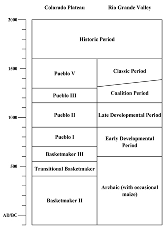
The timing of the settlement changes has strong climatic overtones (see Climate). A significant drought in the mid-twelfth century was felt across north-central New Mexico. Many farming communities failed and were abandoned, and the centralized ceremonial system of Chaco ceased (although Chaco religious practice persisted at local and regional levels). The same drought crisis was felt in the Rio Grande Valley, and farmers started to look for field locations with more rainfall, often at higher elevations. The 1190s also marked the onset of a continent-wide cold period as seen in both tree-ring records from the Pikes Peak area of Colorado and the San Francisco Peaks area of northern Arizona. By the mid-thirteenth century, tree-ring growth records from throughout the northern Southwest indicate that a qualitative change in climate had taken place. This change has been interpreted as a failure of monsoon rainfall reliability in the greater Four Corners region, but with apparent improved moisture conditions to the south. The poor farming conditions in the Four Corners coincide with the start of a 250-300 year period of good farming climate in the Galisteo Basin.
Archaeologists initially tried to link the population boom in the Galisteo Basin (and places like the Pajarito Plateau) with the abandonment of the Four Corners area. This is partially true, but the picture is complex. Galisteo Basin colonization begins before the major abandonment of the Four Corners region, and the first population sources appear to be relatively local. Pottery technology and design at early Coalition sites across the basin suggest that migrants were from the Santa Fe area, the Rio Grande Valley from Cochiti south to Albuquerque, and even from the Pecos River Valley. The contemporary settlers on the northern Pajarito Plateau appear to have moved upslope from the Española Basin, while the settlers on the southern Pajarito Plateau appear to have moved up from the Rio Jemez Valley, possibly including an early wave of refugees from the southern San Juan Basin.
In the Galisteo Basin, homesteads progressively gave way to small hamlets, including sites such as Burnt Corn. This aggregation into hamlets and small villages such as Las Madres, Las Colinas, and Arroyo Hondo proceeded through the fourteenth century, during what is described as the Classic period elsewhere in the Rio Grande Valley. During both the thirteenth and fourteenth centuries, Galisteo Basin potters adapted to local resources and produced what has become known as varieties of Galisteo Black-on-white. While some other Rio Grande Valley populations made a transition to large villages and began making Glaze Ware or Biscuit Ware pottery after AD 1325, populations in the Galisteo Basin maintained their “Coalition period” way of life until around AD 1400.
Classic Period (AD 1325/1400-1540/1600)
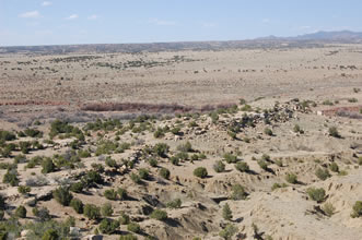
Dramatic changes took place in the cultural landscape of the Galisteo Basin around AD 1400. The number of settlements was reduced, accompanied by a large increase in village size, so that villages in this period consist of from hundreds to thousands of rooms. Eight large villages were formed within the basin, and the villages of La Cieneguilla, Paako, Tonque, and Pecos lie outside of the basin boundaries but were part of the overall social and economic network of the period.
The villages consist of multiple roomblocks surrounding and defining plaza areas. Each village has a complex history, with roomblocks being constructed, abandoned, and then reconstructed through the ensuing centuries. This pattern means that momentary population sizes were probably smaller than the total site size would suggest, but not by very much. Pueblo San Marcos has been studied by Professor Ann Ramenofsky and her students from the University of New Mexico, using pottery on and near the site surface to determine the dating sequence within the site. Their work is reflected in the accompanying maps that show the changes in village occupation from the fourteenth through seventeenth centuries. The dark areas are roomblocks, and the yellow background identifies the areas that were associated with particular pottery types.
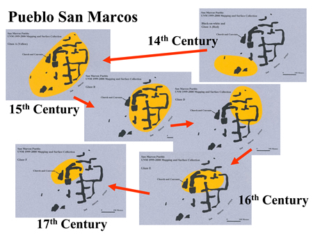 The San Marcos history reflects
the rhythm of most of the village sites. The largest population sizes are
associated with pottery types Glaze A Yellow, Glaze B, and Glaze C, which in
turn represent the time period between about AD 1400 and 1480. By Glaze D
times, populations shrank, and they stayed small through Glaze E. This decline
in population occurred at the very end of the fifteenth century and carried
through the arrival of Spanish Colonists (the early seventeenth century). The
Spanish mission at San Marcos was established when Glaze E was popular and
continued as the pottery changed to Glaze F.
The San Marcos history reflects
the rhythm of most of the village sites. The largest population sizes are
associated with pottery types Glaze A Yellow, Glaze B, and Glaze C, which in
turn represent the time period between about AD 1400 and 1480. By Glaze D
times, populations shrank, and they stayed small through Glaze E. This decline
in population occurred at the very end of the fifteenth century and carried
through the arrival of Spanish Colonists (the early seventeenth century). The
Spanish mission at San Marcos was established when Glaze E was popular and
continued as the pottery changed to Glaze F.
In the case of San Marcos, occupation appears to have been relatively continuous from the late 14th century through the Pueblo Revolt of 1680. This is not true of the large villages further to the south. Pueblos Largo, Colorado, She, Blanco, and San Lazaro all appear to have been abandoned through at least some of the early sixteenth century. Pottery and historic records indicate minor seventeenth century occupations at Pueblos She and Blanco, while seventeenth century missions were established at Pueblos San Lazaro, Galisteo, and San Cristobal as well as the mission at San Marcos. In all cases, the Galisteo Basin pueblos were at their largest in the middle of the fifteenth century, each with multiple occupied plazas and populations in the hundreds to thousands.
The time defined as the Classic period in the Galisteo Basin coincides with two regional phenomena that have important expressions in the Basin: rock art and glaze ware pottery. Coincident with the aggregation of population into the large pueblos was a significant change in rock art imagery. Faces of a wide range of characters represent expressions of katsina religious organizations, and numbers of images can easily run in the thousands near some of the large pueblos. Warrior depictions are also common, leading to a sense that the pueblo residents felt that they were under serious threat at least part of the time. Both katsina and warrior imagery are present for the first time in the Galisteo Basin in the social settings of these dense villages.
Glaze ware is a departure from the black-on-white dominance of northern Rio Grande pottery production in the fourteenth century and earlier. Copper and lead based paints were used on red background colors in the Western Pueblo region in the thirteenth century, and the technology was adopted in the greater middle Rio Grande region in the fourteenth century. Glaze-on-red pottery was imported into the Galisteo Basin while local potters continued to produce black-on-white pottery, but local availability of lead and changing cultural aesthetics resulted in a rapid switch to glaze ware production by Galisteo Basin potters at the turn of the fifteenth century. Yellow background colors became more popular than red, and banded geometric patterns were augmented by stylized bird and other symbols in polychrome representations. By the early-to-mid fifteenth century, glaze ware pottery, especially from the western Galisteo Basin pueblos, were being produced in quantity and were being traded up and down the Rio Grande corridor.
The florescence in art and craft
was seemingly short lived in the Galisteo Basin. The early sixteenth century
saw decreases in population and abandonments at the Galisteo Basin Pueblos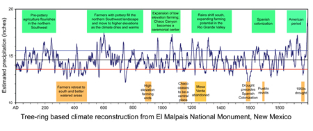 and
more broadly throughout the northern Rio Grande province. These declines are
intriguing because they again coincide with tree-ring evidence of climate
change. At some time around AD 1500, the pattern of tree-growth on the Colorado
Plateau as a whole returns to the pre-AD 1200 pattern. This suggests that the
monsoon rains returned to the Four Corners area, and that the period of good
agricultural conditions in the Galisteo Basin was coming to an end. After the
arrival of Spanish colonists in the early seventeenth century, mission
communities were established at the surviving pueblos and introduced livestock
and the new crops of wheat and rye. The Pueblo Revolt eliminated many
components of the European-based economy, and by the time of the Reconquest at
the end of the seventeenth century, the abandonment of all of the Galisteo Basin
pueblos by farming communities was complete.
and
more broadly throughout the northern Rio Grande province. These declines are
intriguing because they again coincide with tree-ring evidence of climate
change. At some time around AD 1500, the pattern of tree-growth on the Colorado
Plateau as a whole returns to the pre-AD 1200 pattern. This suggests that the
monsoon rains returned to the Four Corners area, and that the period of good
agricultural conditions in the Galisteo Basin was coming to an end. After the
arrival of Spanish colonists in the early seventeenth century, mission
communities were established at the surviving pueblos and introduced livestock
and the new crops of wheat and rye. The Pueblo Revolt eliminated many
components of the European-based economy, and by the time of the Reconquest at
the end of the seventeenth century, the abandonment of all of the Galisteo Basin
pueblos by farming communities was complete.
The apparent population increase through the middle of the fifteenth century and then decrease through the sixteenth seen in the Galisteo Basin mirrors the population history of New Mexico as a whole. Whether due to economic failures (climate change expressed as prolonged drought) or due to waves of disease spreading northward from the Spanish conquest of Mexico, the Native American population of New Mexico was perhaps half or less by the time of the sixteenth century entradas and was even smaller at the 1598 colonization of the region.

Featured Site
Pueblo Galisteo
The huge Pueblo Galisteo was the last and one of the least extensively excavated of the sites studied by Nels C. Nelson...
More about Pueblo Galisteo »© New Mexico Office of Archaeological Studies, a division of the New Mexico Department of Cultural Affairs.
The Center for New Mexico Archaeology
7 Old Cochiti Road
Santa Fe, NM 87507
505-476-4404
Fax: 505-476-4448