
Pueblo Galisteo
Galisteo Basin Sites
- Lamy Jct
- Lower Arroyo Hondo Pueblo
- El Camino Real
- Chamisa Locita
- El Crestón
- Espinoso Ridge Pueblo
- La Cienega Pueblo (LA 3)
- La Cienega Pithouse Village
- La Cieneguilla Pueblo (LA 16)
- La Cieneguilla Petroglyphs
- Manzanares Pueblo
- Paa-ko
- Petroglyph Hill
- Pueblo Blanco
- Pueblo Colorado
- Pueblo Galisteo
- Pueblo Largo
- Pueblo San Cristóbal
- Pueblo San Lazaro
- Pueblo Shé
- Rote Chert Quarry
- San José de Las Huertas
- Upper Arroyo Hondo Pueblo
- Pueblo San Marcos
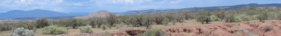
The huge Pueblo Galisteo was the last and one of the least extensively excavated of the sites studied by Nels C. Nelson in 1912 (Nelson 1914:103–112)—he dug “only” 25 rooms.
It is one of the signature sites of the Galisteo Basin, as is clearly reflected in its name. The pueblo (LA 26) was almost completely constructed of adobe. A few stone wall base alignments are visible, but the site is primarily manifested by very large adobe mounds. In contrast, on the rock promontory above the adobe pueblo and across the Rio Galisteo is its ancestral site, Pueblo Las Madres (LA 25), largely constructed of stone.
Pueblo Galisteo has a large footprint—there was little topography to constrain its size. Nelson estimated a total of 1,580 rooms in 26 separate roomblocks, six of which appear to be remnants of the historic period. As mapped by Nelson, the earlier roomblocks are oriented north-south, while the later blocks are on a southeast-northwest axis. For being nearly all adobe, the mounds are quite tall, some on the east nearly 2.5 m high.

Including Las Madres, which had 60 rooms, Pueblo Galisteo had at least four temporal phases: establishment at Las Madres in the 1200s (probably also El Pipo, see below); movement to the valley floor below, establishing the western adobe roomblocks; continued large-scale
occupation after the arrival of the Spaniards, with establishment of the large
church; and the post revolt period, with reduced occupation and construction of
a smaller church to replace the one destroyed in the revolt and which served
the dwindling, reoccupied pueblo until the 1780s (Kessell 1980:232–234). Two
Spanish missions were established by Fray Alonso Peinado in 1610–1611 at Pueblos
San Marcos and Galisteo. Nelson (1914:107) notes that Spanish chronicles describe a “handsome temple,”  which he nonetheless had difficulty finding. OAS mapped in the area of Nelson’s Mound XXIII and are quite confident that that is the location of the churches based on consultation with James Ivey and Cordelia Snow. They believe that they have
identified the location of the bell tower (bell towers?) and the apse. An overlay of other mission plans on this area fits quite nicely. Ceramics include all of the Rio Grande Glaze groups (A to F), and except for brief periods, the site was occupied from the last half of the 1200s to 1794.
which he nonetheless had difficulty finding. OAS mapped in the area of Nelson’s Mound XXIII and are quite confident that that is the location of the churches based on consultation with James Ivey and Cordelia Snow. They believe that they have
identified the location of the bell tower (bell towers?) and the apse. An overlay of other mission plans on this area fits quite nicely. Ceramics include all of the Rio Grande Glaze groups (A to F), and except for brief periods, the site was occupied from the last half of the 1200s to 1794.
Galisteo is probably the best historically documented of the GBASPA sites. Early Spanish documents frequently mention Pueblo Galisteo, which has been tentatively identified as Pueblo
Ximena, which was still occupied in 1540 when visited by Coronado. Castaño de Sosa saw the village in 1590 and called it San Lucas. Oñate
visited the pueblo in 1598 and renamed it Santa Ana, but the name was changed to Santa Cruz de Galisteo. The pueblo participated in the Pueblo Revolt in 1680 and was abandoned when the populace, fearing reprisals, moved to Santa Fe, where they stayed until 1693, yielding the city to Don Diego de Vargas after a bitter
fight. Many were killed or sold into slavery by de Vargas. In 1706 Governor Cuevo y Valdes collected the remnants, then living at Tesuque, and reestablished the pueblo under the name of Santa María de Galisteo.  Ninety Tano Indians were moved at that time. In 1782 there were 52 families, but by 1794, smallpox and Comanche raids forced its inhabitants to move to Santo Domingo Pueblo.
Pueblo Galisteo is one of several Galisteo pueblos where the Spanish established missions with churches. This photo shows a project conducted by the Office of Archaeological Studies mapping the church area.

Featured Site
Chamisa Locita
Chamisa Locita (LA 4) is a Coalition-period residential complex first recorded by Nels Nelson in 1914...
More about Chamisa Locita »© New Mexico Office of Archaeological Studies, a division of the New Mexico Department of Cultural Affairs.
The Center for New Mexico Archaeology
7 Old Cochiti Road
Santa Fe, NM 87507
505-476-4404
Fax: 505-476-4448