
Pueblo Shé
Galisteo Basin Sites
- Lamy Jct
- Lower Arroyo Hondo Pueblo
- El Camino Real
- Chamisa Locita
- El Crestón
- Espinoso Ridge Pueblo
- La Cienega Pueblo (LA 3)
- La Cienega Pithouse Village
- La Cieneguilla Pueblo (LA 16)
- La Cieneguilla Petroglyphs
- Manzanares Pueblo
- Paa-ko
- Petroglyph Hill
- Pueblo Blanco
- Pueblo Colorado
- Pueblo Galisteo
- Pueblo Largo
- Pueblo San Cristóbal
- Pueblo San Lazaro
- Pueblo Shé
- Rote Chert Quarry
- San José de Las Huertas
- Upper Arroyo Hondo Pueblo
- Pueblo San Marcos
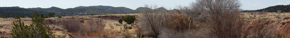
Pueblo Shé is one of the largest Galisteo pueblos.
It is located adjacent to the Arroyo de la Jara, downstream
from Pueblo Colorado. The principal occupation is the large Classic-period (AD
1375–1500) village of Pueblo Shé proper. Nelson (1914) reports 5 areas of
mounded refuse, 14 roomblocks, and estimated 1,543 ground floor rooms. Linear
and L-shaped roomblocks are arranged to define a minimum of seven enclosed
plazas. Two additional east-oriented plazas are also present. Ten of these
roomblocks appear to form an articulated building complex. This configuration
of roomblocks is  defined on the north by three east-west-oriented linear roomblocks and two refuse mounds. Nelson excavated 28 rooms, dispersed about the
roomblocks. Individual refuse mounds are also located on the west and south sides of this building complex. A single kiva depression was observed in the northeast enclosed plaza, and an additional three or more are likely in the other plaza areas. The four remaining roomblocks are north of this central complex and seem to represent autonomous dwelling units, which may represent the first durable architectural elements at the site. Together, this core
architectural area measures 480 m north-south by 300 m east-west with a continuous scatter of artifacts extending an additional 320 m east, terminating at the deeply incised Arroyo de la Jara. This dispersed artifact scatter likely represents the location of agricultural fields. Ceramic cross-dating suggests that the principal occupation occurred between AD 1325 and 1500.
defined on the north by three east-west-oriented linear roomblocks and two refuse mounds. Nelson excavated 28 rooms, dispersed about the
roomblocks. Individual refuse mounds are also located on the west and south sides of this building complex. A single kiva depression was observed in the northeast enclosed plaza, and an additional three or more are likely in the other plaza areas. The four remaining roomblocks are north of this central complex and seem to represent autonomous dwelling units, which may represent the first durable architectural elements at the site. Together, this core
architectural area measures 480 m north-south by 300 m east-west with a continuous scatter of artifacts extending an additional 320 m east, terminating at the deeply incised Arroyo de la Jara. This dispersed artifact scatter likely represents the location of agricultural fields. Ceramic cross-dating suggests that the principal occupation occurred between AD 1325 and 1500.

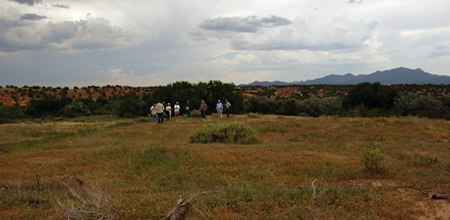
1994 aerial view of Pueblo Shé; note the enclosing wall east of the roomblocks.
A concentration of earlier pottery including mineral and organic painted white wares, red and buff slipped glaze wares, and micaceous utility wares is present along the north central limit of the site. Other early types observed include Bandelier Black-on-gray and Santa Fe Black-on-white. Limited evidence of architectural remains such as scattered cobbles among intervening boulders hints at the presence of jacal or adobe structures. Another scatter of artifacts and cobbles lies immediately to the east and southeast. This concentration of cobbles and artifacts is more clearly delimited with rubble, strongly suggesting the presence of a small adobe or jacal surface structures. Ceramic types observed in this area include Santa Fe Black-on-white and Agua Fria Glaze-on-red. Combined, these two locations indicate that the initial Puebloan occupation of this site began during the late Coalition and early Classic periods (AD 1275–1375), perhaps as a farmstead.
Other prehistoric features within the site boundaries include two reservoirs, three circular features interpreted as shrines, and several rock alignments. Nelson notes on his site map that one reservoir is 2,000 ft east northeast of the pueblo and the other 1,200 ft west of the pueblo. The reservoir to the northeast is represented by a dense pile of debris including artifacts, charcoal-stained soil, and sandstone rubble placed across a main tributary of the incised arroyo, which has since been breached. The presence of mature cottonwood trees suggests this is also the location of the spring noted on the site map. This feature is described as being constructed of soil and sandstone slabs; the ground surface is littered with artifacts. Both reservoirs appear to have incorporated refuse in their construction.
A world shrine is present on the ridge south of the pueblo. This location offers a commanding view of the village and surrounding topography. A probable formal path or road leads up the ridge to this feature. Two similar features are near the northeast corner of the roomblocks. These features are described by Nelson as kivas and on the nomination form as “two contiguous, circular above-ground shrines.”
One of the most intriguing aspects of this site is a wall half a kilometer long on the floodplain east of the pueblo. It is built of large sandstone blocks, representing a huge amount of labor. This feature articulates with the ridgeline south and east of the roomblock and extends east approximately 110 m, where it rounds to the north. The alignment of boulders extends nearly 500 m north from this point, rounding again back to the west. The northern arm extends approximately 180 m west, where it articulates with the two shrines. A smaller section of wall overlapping the terminal end of the boulder feature and a portion of the northern east-west wall are illustrated on Nelson’s map. Nelson also illustrates a long section of the east-west wall continuing west into the hillslope. The function and even the age of this landscape feature are not certain; the wall seems likely to have served to demarcate the area to the east as outside the pueblo.
The historic component consists primarily of the remains of a nineteenth-century homestead and associated features, including a house, an horno, and a rectilinear enclosure defined by a low stone wall. A corral may also be present in the boulder field north of the house mound. The rectilinear feature may have been constructed in an attempt to improve the adjacent spring or impound its water. A second rectilinear enclosure, less clearly defined, is adjacent to a north-south-trending mound associated with Roomblock II. This may also represent a historic feature. Few artifacts associated with this component were identified. This occupation took advantage of readily available materials of the prehistoric component to build these features.
This site is HPD No. 115 in the State Register of Cultural Properties. It is entirely privately owned.

Featured Site
Pueblo San Marcos
Pueblo San Marcos was one of the largest prehistoric adobe settlements in North America...
More about Pueblo San Marcos »© New Mexico Office of Archaeological Studies, a division of the New Mexico Department of Cultural Affairs.
The Center for New Mexico Archaeology
7 Old Cochiti Road
Santa Fe, NM 87507
505-476-4404
Fax: 505-476-4448