
Pueblo San Marcos
Galisteo Basin Sites
- Lamy Jct
- Lower Arroyo Hondo Pueblo
- El Camino Real
- Chamisa Locita
- El Crestón
- Espinoso Ridge Pueblo
- La Cienega Pueblo (LA 3)
- La Cienega Pithouse Village
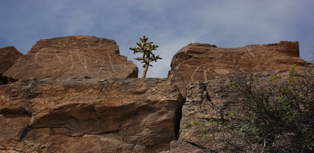
- La Cieneguilla Pueblo (LA 16)
- La Cieneguilla Petroglyphs
- Manzanares Pueblo
- Paa-ko
- Petroglyph Hill
- Pueblo Blanco
- Pueblo Colorado
- Pueblo Galisteo
- Pueblo Largo
- Pueblo San Cristóbal
- Pueblo San Lazaro
- Pueblo Shé
- Rote Chert Quarry
- San José de Las Huertas
- Upper Arroyo Hondo Pueblo
- Pueblo San Marcos
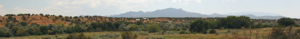
Pueblo San Marcos was one of the largest prehistoric adobe settlements in North America, consisting of an estimated 2,000 adobe rooms in 22 roomblocks, some thought to be two and three stories high, enclosing ten to twelve plazas; nine estimated midden areas; ten estimated kiva depressions; the remains of an early seventeenth-century Spanish Colonial mission complex; a possible cemetery; agricultural features southeast and west of the site’s main architectural features; at least two Spanish Colonial–period metallurgical smelting features; and a sherd and lithic artifact scatter that extends from the central architectural portion of the site in all directions.
The architectural features and trash middens that make up the central portion of the site cover an estimated 24.3 ha (60 ac), though only portions of the site are thought to have been
occupied at any one time. Nels C. Nelson of the American Museum of Natural
History first visited and conducted test excavations at Pueblo San Marcos in  1912. and, in 1915, after obtaining permission from site owner Levi Hughes of
Santa Fe, he tested nearly every roomblock across the site. Nelson (1919) and
Eddy et al. (1996) thought that settlement had started in the southwest portion
of the site nearest the springs, and from there moved north and east, finally
retreating back to the area of the mission church in the northwestern portion
of the site. Based on ceramic analyses and limited dendrochronology studies,
Pueblo San Marcos dates from the mid to late AD 1200s to 1680. The site’s
proximity to Cerrillos Hills, a source of highly valued turquoise and lead
deposits, as well as an abundance of turquoise and lead-glazed pottery found on
the site’s surface, has led many scholars to believe that Pueblo San Marcos
controlled the Cerrillos turquoise and lead mines for many centuries. Chemical
analyses of ceramics from Pueblo San Marcos and other pueblos in the Galisteo
Basin indicate the village was a major manufacturing center for the ceramic
types included in the Rio Grande Glazewares. This pottery was exported in large
quantities from the village to other pueblos in the upper Rio Grande area and
possibly as far away as the southern Plains.
1912. and, in 1915, after obtaining permission from site owner Levi Hughes of
Santa Fe, he tested nearly every roomblock across the site. Nelson (1919) and
Eddy et al. (1996) thought that settlement had started in the southwest portion
of the site nearest the springs, and from there moved north and east, finally
retreating back to the area of the mission church in the northwestern portion
of the site. Based on ceramic analyses and limited dendrochronology studies,
Pueblo San Marcos dates from the mid to late AD 1200s to 1680. The site’s
proximity to Cerrillos Hills, a source of highly valued turquoise and lead
deposits, as well as an abundance of turquoise and lead-glazed pottery found on
the site’s surface, has led many scholars to believe that Pueblo San Marcos
controlled the Cerrillos turquoise and lead mines for many centuries. Chemical
analyses of ceramics from Pueblo San Marcos and other pueblos in the Galisteo
Basin indicate the village was a major manufacturing center for the ceramic
types included in the Rio Grande Glazewares. This pottery was exported in large
quantities from the village to other pueblos in the upper Rio Grande area and
possibly as far away as the southern Plains.
The site’s Spanish mission complex was started in 1610–1611 by Fray Alonso Peinado, at which time the village and the immediate area were patented as the San Marcos Pueblo Grant by the king of Spain. The village played an active role in the Pueblo Revolt of 1680 and is
thought to have been abandoned shortly after the  destruction of the mission
church and convento. An estimated 600 people lived at Pueblo San Marcos, known as Ya’atze in the Keres language, shortly before the Pueblo Revolt (Sando 1979). According to oral history and descendants of Ancestral Puebloan peoples, the inhabitants of Pueblo San Marcos
moved south and west to join Santo Domingo, Cochiti, San Felipe, and Hopi.
Recent research suggests there may have been some Puebloan reoccupation of the
site following the Revolt, but its extent and timing is uncertain. Today
members of Santo Domingo, Cochiti, San Felipe, and Tesuque Pueblos, as well as
the Hopi Tribe, claim Pueblo San Marcos as an ancestral site and continue to use
the area for traditional purposes.
destruction of the mission
church and convento. An estimated 600 people lived at Pueblo San Marcos, known as Ya’atze in the Keres language, shortly before the Pueblo Revolt (Sando 1979). According to oral history and descendants of Ancestral Puebloan peoples, the inhabitants of Pueblo San Marcos
moved south and west to join Santo Domingo, Cochiti, San Felipe, and Hopi.
Recent research suggests there may have been some Puebloan reoccupation of the
site following the Revolt, but its extent and timing is uncertain. Today
members of Santo Domingo, Cochiti, San Felipe, and Tesuque Pueblos, as well as
the Hopi Tribe, claim Pueblo San Marcos as an ancestral site and continue to use
the area for traditional purposes.
A long history of mapping projects undertaken at Pueblo San Marcos and the surrounding area beginning in the early twentieth century has resulted in a fairly good understanding of the site’s extent and layout. Projects by the School of American Research and the University of Colorado have studied the extensive agricultural landscape around San Marcos which includes pebble-mulch fields, rock-bordered gardens, borrow pits, terraces, and check dams. University of New Mexico faculty and students mapped the majority of the site in 1997, producing detailed maps. All of Nelson’s test trenches remain untreated across the site, all of them having filled in naturally over time. Some remain visible as swales in the site’s surface. Staff from the American Museum of Natural History, helped define the mission church and attached convento complex at Pueblo San Marcos. The San Marcos convento plan follows one used at many Spanish missions in New Mexico.
The site is currently listed as number 114 in the State Register of Cultural Properties. The ownership of the site is very complex, including portions held by the Archaeological Conservancy, the State of New Mexico, and multiple private individuals.

Featured Site
El Crestón
The Crestón is a long geologic feature that extends to very near Pueblo Blanco...
More about El Crestón »© New Mexico Office of Archaeological Studies, a division of the New Mexico Department of Cultural Affairs.
The Center for New Mexico Archaeology
7 Old Cochiti Road
Santa Fe, NM 87507
505-476-4404
Fax: 505-476-4448