
Chamisa Locita
Galisteo Basin Sites
- Lamy Jct
- Lower Arroyo Hondo Pueblo
- El Camino Real
- Chamisa Locita
- El Crestón
- Espinoso Ridge Pueblo
- La Cienega Pueblo (LA 3)
- La Cienega Pithouse Village
- La Cieneguilla Pueblo (LA 16)
- La Cieneguilla Petroglyphs
- Manzanares Pueblo
- Paa-ko
- Petroglyph Hill
- Pueblo Blanco
- Pueblo Colorado
- Pueblo Galisteo
- Pueblo Largo
- Pueblo San Cristóbal
- Pueblo San Lazaro
- Pueblo Shé
- Rote Chert Quarry
- San José de Las Huertas
- Upper Arroyo Hondo Pueblo
- Pueblo San Marcos
Chamisa Locita (LA 4) is a Coalition-period residential complex first recorded by Nels Nelson in 1914.
The site consists of a long, primary east-west mound with four additional mounds abutting it perpendicularly to the south. This roughly E-shaped configuration defines two primary plazas sharing the long east-west mound. These plazas are partially enclosed by additional detached mounds to the south. The detached mounds may define additional, but more informal plaza areas. Mera’s sketch map from the late 1920s actually depicts two contiguous but spatially separated plazas (see Mera map). However, Nelson excavated two rooms in Mera's gap between the two plazas, showing that the long east-west roomblock was actually continuous and common to both plazas. Nelson depicted 16 roomblocks, and the scale of Nelson's map suggests that there were between 280 to 300 rooms.
")
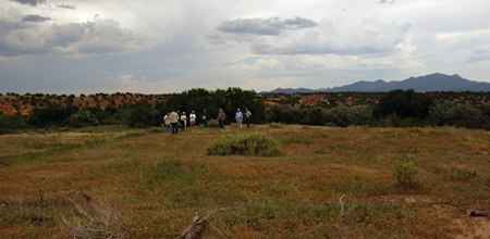
Hilltop shrine associated with Chamisa Locita.
Several roomblocks were probably two stories tall. Nelson recorded a possible kiva just south of Roomblock IX, but this possible kiva is not visible today. Mera did not record any kivas in the late 1920s. The roomblocks cover an area of 350 ft north-south by 450 ft east-west according to Nelson=s measurements. Nelson noted that there were no major refuse mounds at the site. Refuse may have been deposited in the arroyos that border the site on the west, south, and southeast. These floodplain deposits would not have survived repeated flooding over time. Five poorly provenienced tree-ring dates span the AD 1313 to 1333 period. Ceramics are primarily organic-painted types consisting mainly of Santa Fe and Galisteo Black-on-white. Glaze sherds are infrequent, suggesting that the occupation did not extend much into the Classic period. Chamisa Locita seems to be a good example of a Coalition-period site with an AD 1200–ca. AD 1350 occupation.
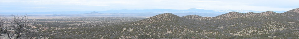
") Chamisa Locita is on a hillslope
between the junction of Arroyo Ancho on the west and Gallina Arroyo on the
south and southeast (Photo 482). These arroyos currently only run during very
wet periods or severe thunderstorms. I-25 currently blocks these arroyos from
their source in the higher foothills to the east and now limits the amount of
runoff that reaches the site area. A spring at the site has been tapped by a
windmill and may have had a stronger flow at the time of occupation. Arable
lands are present along the floodplains of these arroyos extending to the
south. The Cañada de Los Alamos arroyo is another source of water, and farmland
is located about one mile east of the site. This arroyo has a much higher and
extensive watershed, and Pueblo Alamo, a contemporary Coalition-period pueblo,
was located nearby along this arroyo. However, this site was abandoned before
Chamisa Locita. The abandonment of Pueblo Alamo would have opened up the
additional water, arable land, and riparian resources along Cañada de Los
Alamos for exploitation by the Chamisa Locita Community.
Chamisa Locita is on a hillslope
between the junction of Arroyo Ancho on the west and Gallina Arroyo on the
south and southeast (Photo 482). These arroyos currently only run during very
wet periods or severe thunderstorms. I-25 currently blocks these arroyos from
their source in the higher foothills to the east and now limits the amount of
runoff that reaches the site area. A spring at the site has been tapped by a
windmill and may have had a stronger flow at the time of occupation. Arable
lands are present along the floodplains of these arroyos extending to the
south. The Cañada de Los Alamos arroyo is another source of water, and farmland
is located about one mile east of the site. This arroyo has a much higher and
extensive watershed, and Pueblo Alamo, a contemporary Coalition-period pueblo,
was located nearby along this arroyo. However, this site was abandoned before
Chamisa Locita. The abandonment of Pueblo Alamo would have opened up the
additional water, arable land, and riparian resources along Cañada de Los
Alamos for exploitation by the Chamisa Locita Community.
Chamisa Locita is advantageously situated in relation to surrounding resources on the landscape. The site is at the margin of two physiographic units: the sharply rising foothills of the Sangre de Cristo Mountains to the east, and the rolling flatlands of the open piedmont slope extending off to the west. The foothills contain shallow rocky soils and bedrock exposures of Precambrian granite, quartz, gneiss, schist, and diabase. The foothills provide a rugged hinterland conducive to prehistoric hunting and gathering activities. The immediate site setting offers water, abundant firewood, and topographic protection from winds that are more highly circulating in the open piedmont to the west. The open piedmont to the west is characterized by more open grasslands and is still the home of numerous pronghorn antelope. The Ancha formation covers much of the piedmont, and this geologic feature is the source of a wide range of potential lithic material in the form of axial gravels and cobbles. Common flaked stone resources include Madera chert, undifferentiated chert, undifferentiated chalcedony, and undifferentiated quartzites.

Featured Site
Pueblo San Marcos
Pueblo San Marcos was one of the largest prehistoric adobe settlements in North America...
More about Pueblo San Marcos »© New Mexico Office of Archaeological Studies, a division of the New Mexico Department of Cultural Affairs.
The Center for New Mexico Archaeology
7 Old Cochiti Road
Santa Fe, NM 87507
505-476-4404
Fax: 505-476-4448