
Pueblo San Cristóbal
Galisteo Basin Sites
- Lamy Jct
- Lower Arroyo Hondo Pueblo
- El Camino Real
- Chamisa Locita
- El Crestón
- Espinoso Ridge Pueblo
- La Cienega Pueblo (LA 3)
- La Cienega Pithouse Village
- La Cieneguilla Pueblo (LA 16)
- La Cieneguilla Petroglyphs
- Manzanares Pueblo
- Paa-ko
- Petroglyph Hill
- Pueblo Blanco
- Pueblo Colorado
- Pueblo Galisteo
- Pueblo Largo
- Pueblo San Cristóbal
- Pueblo San Lazaro
- Pueblo Shé
- Rote Chert Quarry
- San José de Las Huertas
- Upper Arroyo Hondo Pueblo
- Pueblo San Marcos
 As at Pueblo Galisteo, the Spanish established a mission and church at San Cristóbal, but here the church was stone rather than adobe and the west apse wall is still standing
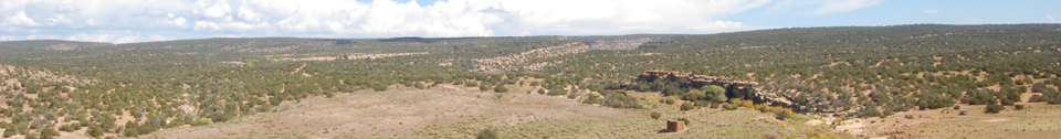
The impressive Pueblo San Cristóbal (LA 80) was the first and most extensively excavated of the sites studied by Nels C. Nelson in 1912.
It differs from many of the pueblos in the Galisteo Basin in its greater use of stone as a building material. It is also noteworthy for its prolific rock art in the adjacent boulder field and cliffs and for the Spanish convento with church wall standing 4 m high. It is on the banks of the Arroyo San Cristóbal, a permanent water source. Nelson identified seventeen roomblocks and estimated 1,645 rooms. He made one of his remarkable maps (1914: Plate I), which also shows a shrine, six middens, eleven plazas, and a reservoir. Nelson excavated 227 rooms (Nelson 1914:113–119), including most or all of Roomblocks I (40 rooms) and III (72 rooms) south of the creek and large numbers in IXb (30 rooms), X (27 rooms), and XIII (12 rooms) up the hill in what he termed the historic pueblo. As was his practice, he excavated at least one room in each roomblock he identified.
Since Nelson (1914) the pueblo has attracted considerable attention, although little or no subsequent documented excavation. Publications include photographic and historic accounts (Mednick 1996), stabilization (Breternitz 1988), and a nomination to the National Register of Historic Places conducted by R. W. Lang in 1977 for the School of American Research (SAR). The SAR conducted a survey in the area of nearly 4,000 acres in 1976 and 1977. Lang’s project divided the site into a number of separate site numbers for various features, such as the roomblocks, the reservoir (LA 28423), the rock art (LA 28553, LA 28578, LA 28579). They recorded a series of tipi rings (LA 28360–LA 28371) outside the cross-mesa wall. The SAR also conducted stabilization in 1977, placing plates in the church wall (SC-SAR-R2F10). Friends of Archaeology and members of the Office of Archaeological Studies staff studied and documented changes and current state of the convento wall.
Museum studies of material include Sullivan analyses of skeletal material collected by Nelson. The OAS, under the auspices of the Galisteo Basin Initiative, has performed detailed  topographic mapping of the church and convento area. The presence of the mission at this
pueblo makes it an outstanding place to study the earliest European–Native American contact. The pueblo was probably in decline at the time of the Spanish establishment there. The pueblo’s residents had an active role in the Revolt of 1680. The pueblo ceased to be occupied after the revolt.
topographic mapping of the church and convento area. The presence of the mission at this
pueblo makes it an outstanding place to study the earliest European–Native American contact. The pueblo was probably in decline at the time of the Spanish establishment there. The pueblo’s residents had an active role in the Revolt of 1680. The pueblo ceased to be occupied after the revolt.
The rock art on the cliffs and in the boulder field north of the pueblo is extraordinary in its variety, abundance, and diversity. This area is often referred to as “world class,” about which there can be little debate. The images from this area are widely known and published (e.g., Mednick 1996; Slifer 2000:155; Schaafsma 1995). The majority of the panels in this area are Puebloan, but examples from earlier periods—the Archaic—are also present.
In addition rock art, the site has a number of other features. Around 100 m from the northeast corner of the roomblocks there is a wall made of huge sandstone slabs set on edge (DSC 1048). This wall crosses the entire mesa between the large drainage that bounds the north side of the pueblo and Arroyo San Cristóbal. Like the surrounding wall at Pecos Pueblo and perhaps the long east wall at Pueblo She, this wall may have demarcated the area outside of which visiting groups were required to stay. There are small enclosures within the wall, and figures are cut into the exposed bedrock near the south end of the wall.
Southwest of the pueblo there is a large flat area cut by some shallow drainages. One of these was dammed by a sizable construction. This area seems  almost inevitably to have been an important agricultural area for the pueblo. Further south of this area there are a few cultural features, including small artifact areas and cut logs.
As a well-watered location, the area around Pueblo San Cristóbal also has a number of historic features. A major irrigation ditch skirts the south and west sides of the pueblo on the north side of the creek and cuts a number of deposits. It passed between the church and the roomblocks and then crossed the major arroyo below the rock-art field by means of an aqueduct structure. This ditch was fed by a now-breached dam, and a heavy-duty head gate remains in place. The ditch was apparently abandoned by the time Nelson worked at the pueblo in 1912, but he did not map it (see Nelson photo comparison).
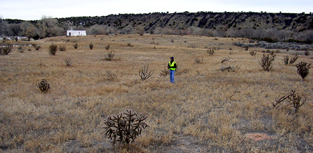
The site is Number 112 on the State Register of Historic Places. It is entirely privately held.

Featured Site
La Cieneguilla Pueblo (LA 16)
La Cieneguilla Pueblo (LA 16) is located on the eastern banks of the Santa Fe River...
More about La Cieneguilla Pueblo (LA 16) »© New Mexico Office of Archaeological Studies, a division of the New Mexico Department of Cultural Affairs.
The Center for New Mexico Archaeology
7 Old Cochiti Road
Santa Fe, NM 87507
505-476-4404
Fax: 505-476-4448